• Nema said the ESIA was inclusive and participatory, with the input and concerns of various stakeholders.
• But conservationists have faulted Nema for what they term engaging into politics at the expense of protecting the environment.
Nema has supported construction of a road cutting through the fragile Aberdare ecosystem, saying it will boost tourism and spur economic growth
“Analysis of route alternatives established that the proposed road is the most cost-effective route to connect Ndunyu Njeru in Nyandarua county to Ihithe in Nyeri county by cutting the travel time by more than one hour and 30 minutes over the other available alternatives," Nema said in a brief.
"This will not only stimulate tourism activities in the Aberdare ecosystem but also spur the economic development of the local communities and surrounding counties.”
On January 5, Nema issued an environmental impact assessment licence to the Kenya National Highways Authority to proceed with the road project through the critical water tower.
But conservationists have faulted Nema for what they term engaging into politics at the expense of protecting the environment.
They say the project will affect the fragile ecosystem.
They support their assertions through a study done earlier by conservation researchers from the universities of Oxford, Nairobi and Amsterdam that pointed out that the upgrade is not only unnecessary but also waste of taxpayers money.
The scientists said the only benefit of the road is slightly reduced travel time and potentially lower fuel costs, between Nyeri-Naivasha and Nyeri-Gilgil.
“Our analysis demonstrates that the new Mau Mau road will reduce travel times by 1.3-6.5 per cent on 11 routes and increase the number of people within 2km of a tarmac road by 177,000,” they said.
The scientists said the study shows there is almost no socio-economic benefit to building a road over the Aberdare Range through the Aberdare National Park.
"There is no evidence that it brings people closer to main roads, or reduces travel time to markets,” they said.
They said building roads in bogs, swamps and peatlands found at the top of Aberdare is also more expensive than in other habitats.
They said the road would also provide an avenue for illegal exploitation of natural resources - including bush meat, illegal wildlife trade and logging.
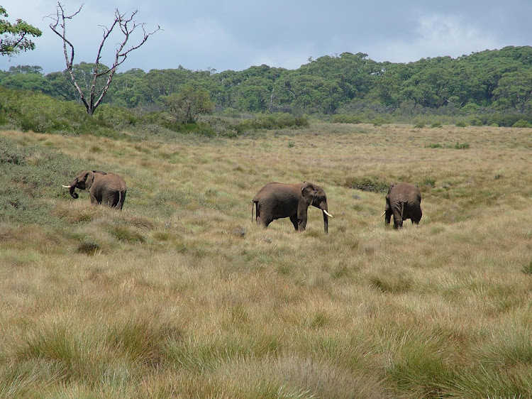
The forest has 63 endemic plants, an important bird area, 1,500 endangered African elephants, the largest remaining population of critically endangered Eastern Mountain Bongo and a small population of endangered black rhino.
Already, conservation NGO, Rhino Ark Charitable Trust, has suggested an alternative road in a bid to save the Aberdare ecosystem.
The NGO said the Ndaragwa-Kariamu alternative, which is 32km, remains the best option.
The proposed 97.8km Aberdare road project covers parts of Nyeri and Nyandarua counties.
The main section starts at Ihithe, takes a southwesterly course through the Nyayo Tea Zone and enters the Aberdare National Park.
The road then emerges from the park at about 33km (Mutubio Gate) and descends through a series of hairpin bends to Kahuruko.
The 10km stretch between Mutubio Gate and Kahuruko is tarmacked.
From Kahuruko, the road continues to descend and ends at its junction with the C69 road at Ndunyu Njeru.
Other road sections included in the project are Njeng'u-Treetops Gate-Amboni, the Ihithe-Kiamutiga-Mukara, the Ark Gate Access, the Munyaka-Koinange-Heni-Mwendandu and the Njoma-Weru road sections, totalling 46km.
Nema said the ESIA was inclusive and participatory, with the input and concerns of various stakeholders, such as conservation organisations, community-based organisations and government agencies.
The authority said the move was aimed at seeking information to inform the salient road design features and appropriate safeguards, such as the inclusion of underpasses, viaducts and overpasses for wildlife crossings and dispersal based on historical wildlife distribution and migratory routes.