Ndaka-ini dam spills over as heavy rains continue

The dam draws its water from the Thika, Githika and Kayuyu rivers.

In Summary
  • The dam has a storage capacity of 70,000,000 cubic metres of water and is 65 metres deep.
  • Areas neighbouring Gondo, Mathioya, Maragua, Sagana, Thika and Chania rivers that have their sources in the Aberdare forest are also set to be affected as they swell and burst banks.
Ndaka-ini dam spill over inlet.
Image: Alice Waithera

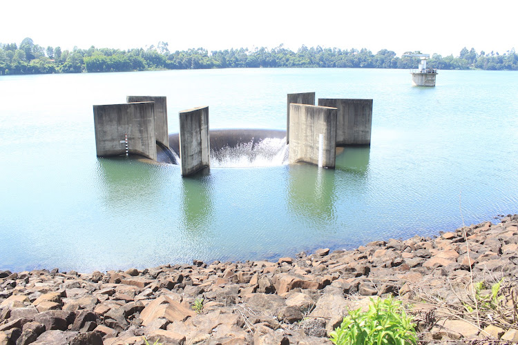
Ndaka-ini dam has started spilling over following the heavy rains that have been experienced in the areas neighbouring the Aberdare forest.

The dam that supplies about 84 percent of the water consumed in Nairobi County and its environs is the biggest reservoir in the country.

It is located in the Gatanga constituency, Murang’a County.

The dam constructed in 1994 has a storage capacity of 70,000,000 cubic metres of water and is 65 metres deep, producing 430,000 cubic metres of water for supply to Nairobi residents.

The dam draws its water from the Thika, Githika and Kayuyu rivers.

According to the county director of meteorology Stanley Kinyua, the area surrounding the dam has been receiving fluctuating levels of rainfall in the last few days but the rainfall exceeded the normal levels, causing the dam to fill up and overflow.

The dam was 98 percent full by 8.00 am today but rains that consistently fell in the area for the better part of the morning filled it up.

“The area received 68 milimetres of rainfall today causing the dam to spill over at 11.30 am,” he said.

The dam last filled up in December 2019, causing a spillover of 15,000 cubic metres of water per second into the Chania and Thika rivers.

Areas neighbouring Gondo, Mathioya, Maragua, Sagana, Thika and Chania rivers that have their sources in the Aberdare forest are also set to be affected as they swell and burst banks, especially in the low-lying downstream areas.

Ndaka-ini dam spill-over outlet.
Image: Alice Waithera

Kinyua urged the relevant government agencies to spread information to people living in downstream areas to be on the lookout for floods.

Meanwhile, the county head of the disaster management team Bilha Wanjiku said her team has been training in preparation for any disasters that may be occasioned by the heavy rains.

“My team has also been trained to deal with chemical, biological, radiological and nuclear threats,” she said.

Murang’a County is one of the regions affected by landslides that have killed tens and displaced hundreds in the last few years.

In May this year, eight homes were destroyed by landslides in Ndurumo village in Mathioya sub-county, while six other families were advised to move to safer grounds after tea farms were swept away in Wanjerere, Kangema sub-county.

In 2020, huge cracks caused by earth movements appeared in Murarandia village, Kahuro sub-county, causing panic among residents and displacing 12 families whose farms started sinking.

Cracks also appeared in Mathioya and Kangema sub-counties as numerous roads were rendered impassable by landslides.

In 2018, four members of a family died after a landslide swept away a house in Inoi village in Kahuro sub-county as they slept.

The landslide stretched for over a kilometre, affecting a tea farm where the four were residing.

WATCH: The latest videos from the Star