The Kenya National Highways Authority has advised motorists to exercise caution while driving between Athi River Interchange and Sabaki
KeNHA said the stretch of the road on Mombasa Road on the route to Nairobi is currently flooded.
“Motorists are urged to exercise extreme caution,” the authority said on X and issued a raft of safety guidelines.
“Drive at reduced speeds to maintain control over your vehicle [and] maintain a safe distance from other vehicles to allow for sudden stops,” KeNHA said.
“Avoid unnecessary lane changes and overtaking. Your safety is our top priority. Drive safely.”
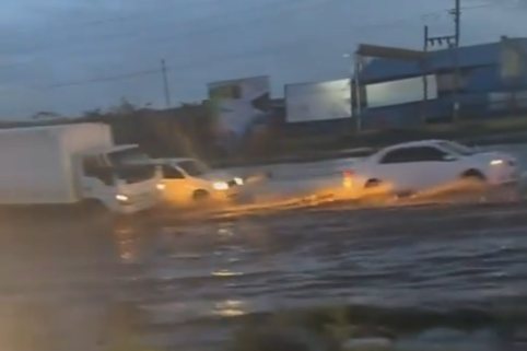
Earlier in the morning, stormwater had rendered Athi River - Namanga Road impassable after the water overtopped Kitengela Bridge.
The water, however, later receded and traffic was restored.
“We, however, urge motorists to be on the lookout while crossing the bridge for any possible overtopping and take necessary precautions,” KeNHA said.
An update issued Wednesday by Nairobi Governor Johnson Sakaja said flash floods occasioned by nightlong rains had affected most roads in the city and disrupted traffic and human movement.
He said the situation was worsened after Ngong River burst its banks leading to heavy flooding to several roads including Ole Odume and Langata Road junction (near T-Mall), Langata South Road, Eastern bypass and Kenyatta Avenue.
“Although we are on the brink of a humanitarian crisis, there is a large-scale coordinated response operation ongoing under my strong leadership,” Sakaja said after visiting some affected areas in the company of several city MPs and local leadership.
“The Red Cross together with our Gender Department is on the ground to protect children and to deliver safe water, nutrition and health services and supplies,” he said.
Kenya Red Cross said the heavy rainfall that pounded several parts Tuesday night led to flash floods resulting in paralysis of businesses in some areas as water filled up spaces within which they operate.
The worst hit include Mukuru, Mathare, Huruma, Ruaraka, Baba Dogo, Bosnia, Umoja 3, Choka, Njiru, Ruai, Utawala, Githurai, Kahawa, Eastern Bypass, Kinoo, Kijabe, Limuru, Ruiru, Graceland, Joska, Kaswito, Kicheko, Mangili, Kenyatta Road, Juja, Kitengela, and Magadi.
The Kenya Meteorological Department in its weekly forecast said most parts of the country would continue receiving rains in the next 24 hours ending Thursday, April 25 at 9 am.
It said areas to be affected in Nairobi include Embakassi East and South which would receive up to 20mm of rain.
The weatherman said Roysambu, Westlands, Lang’ata, Kibera, Dagoretti North and South, Makadara, Starehe, Kamukunji and Ruaraka should brace for up to 50mm of rain.