
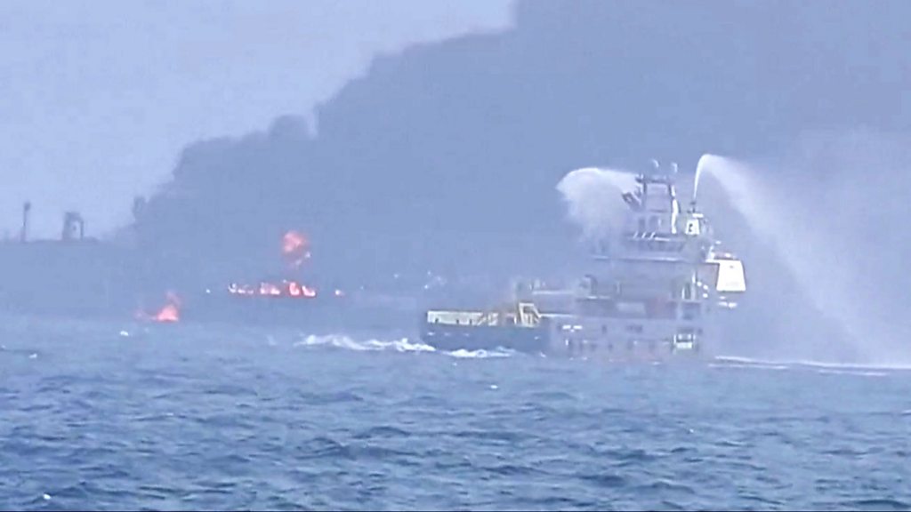
A crew member is yet to be accounted for after an oil tanker and a cargo ship collided in the North Sea Monday morning.
The collision involved the US-registered Stena Immaculate- which was transporting jet fuel on behalf of the US military- and the Portuguese-flagged Solong transporting highly toxic chemicals.
According to the UK Coastguard, some 36 others were rescued, with one person hospitalised.
The missing crew member had been onboard the Solong.
One of the men who was on the oil tanker told BBC News that the Solong came out of the blue and collided with the Stena Immaculate at 16 knots.
Tracking data suggests that Stena Immaculate was at anchor when the accident occurred.
Ship collisions in the North Sea are relatively uncommon but not rare.
On October 24, 2023, two cargo ships, the Isle of Man-flagged Verity and the Bahamian-flagged Polesie, collided in the North Sea near Germany's Heligoland Islands, with the Verity sinking.
Two people were killed, while two others are still missing and considered deceased.
About North Sea
The North Sea lies between Great Britain, Denmark, Norway, Germany, the Netherlands, Belgium, and France.
It is on the European continental shelf and connects to the Atlantic Ocean through the English Channel in the south and the Norwegian Sea in the north.
The North Sea is one of the busiest sea areas when it comes to shipping, fisheries, oil and gas exploration, sand extraction, and offshore wind energy.
It is one of the most treacherous seas in the world for ships to navigate.
It is often rough, stormy, and covered by thick fogs.
It is also shallow and laced by swift, tangled currents.
What guides the paths, and who controls?
The movement of ships is guided and controlled by several systems and authorities to ensure safe navigation and prevent collisions.
International Regulations for Preventing Collisions at Sea (COLREGs) set global navigation rules.
SOLAS (Safety of Life at Sea) ensures that ships follow safety and communication standards.
COLREGs were established by IMO in 1972 to provide standardised rules to ensure safe navigation and prevent collisions between vessels worldwide.
One of the most important innovations in the 1972 COLREG was the recognition given to traffic separation schemes.
Rule 10 gives guidance in determining safe speed, the risk of collision and the conduct of vessels operating in or near traffic separation schemes.
These regulations apply to all ships on the high seas and navigable waters connected to the open ocean.
COLREGs emphasise safe navigation through key principles such as maintaining a proper lookout, traveling at a safe speed, and assessing the risk of collision.
Ships must use all available means, including radar and sight, to detect and avoid potential hazards.
Clear and early actions must be taken to prevent close-quarter situations.
The rules also define right-of-way scenarios where power-driven vessels must give way to sailing vessels, and in crossing situations, the vessel on the starboard (right) side has priority.
Overtaking vessels, on the other hand, must keep clear of the ship being overtaken.
Ships navigating narrow channels or traffic separation schemes (TSS) must follow designated routes and avoid obstructing larger, less maneuverable vessels.
Additionally, COLREGs mandate the use of navigation lights and sound signals to communicate a vessel’s status, direction, and actions.
These signals help ships operate safely, especially in poor visibility conditions such as fog.
In summary, ships use these IMO rules for navigation;
Traffic Separation Schemes (TSS)
These are like "highways" for ships, managed by the International Maritime Organization (IMO).
The Dover Strait TSS is one of the busiest and most strictly controlled in the world.
It was established by IMO to regulate and separate ship traffic to reduce the risk of collisions in one of the world's busiest shipping lanes.
Vessel Traffic Services (VTS)
Coastal states operate VTS centers that monitor ship movements using radar, Automatic Identification System (AIS), and radio communications.
AIS is mandatory for large vessels and broadcasts ship identity, position, speed, and course.
It helps ships and authorities track movements in real time.
Some of the common ones are the UK’s Maritime and Coastguard Agency (MCA), the Netherlands’ Rotterdam VTS and Germany’s Wadden Sea and Elbe VTS.
Pilots and Port ControlLarge ships entering or leaving major ports must take a local pilot onboard for safe navigation.
Harbor masters and port control coordinate vessel movements.


